ទំព័រគំរូ:ប្រអប់ព័ត៌មាន ជម្លោះយោធា/doc
Appearance
| This is a documentation subpage for ទំព័រគំរូ:ប្រអប់ព័ត៌មាន ជម្លោះយោធា. It may contain usage information, categories and other content that is not part of the original ទំព័រគំរូ page. |
Usage
[កែប្រែ]Military conflict infobox
[កែប្រែ]| Battle of Lützen | |||||||
|---|---|---|---|---|---|---|---|
| ផ្នែកនៃthe Thirty Years' War | |||||||
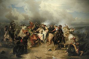
 The Battle of Lützen by Carl Wahlbom shows the death of King Gustavus Adolphus on November 16, 1632. | |||||||
| |||||||
| ភាគីសង្គ្រាម | |||||||
| Sweden, Protestant German states |
Holy Roman Empire, Catholic German states | ||||||
| មេបញ្ជាការ និង មេដឹកនាំ | |||||||
| Gustavus Adolphus †, Bernhard of Saxe-Weimar |
Albrecht von Wallenstein, Gottfried zu Pappenheim † | ||||||
| កម្លាំង | |||||||
| 12,800 infantry, 6,200 cavalry, 60 guns |
10,000 infantry, 7,000 cavalry, 24 guns | ||||||
| សហេតុភាព និង ការខាងបង់ | |||||||
| 3,400 dead, 1,600 wounded or missing |
3,000–3,500 dead or wounded | ||||||
A military conflict infobox (sometimes referred to as a warbox) may be used to summarize information about a particular military conflict (a battle, campaign, war, or group of related wars) in a standard manner.
The infobox should be added using the {{infobox military conflict}} template, as shown below:
{{infobox military conflict
| conflict = First Cambodian-Siamese (1530-1531)
| partof =
| image =
| caption =
| date = 1530-1531 A.D
| place = Cambodia
| coordinates =
| map_type =
| latitude =
| longitude =
| map_size =
| map_caption =
| map_label =
| territory =
| result = Cambodian Victory
| status =
| combatant1 =
| combatant2 =
| combatant3 =
| commander1 = Ang Chan I
| commander2 = Maha Chakkraphat
| commander3 =
| units1 =
| units2 =
| units3 =
| strength1 =
| strength2 =
| strength3 =
| casualties1 =
| casualties2 =
| casualties3 =
| notes =
| campaignbox =
Microformat
[កែប្រែ]
The HTML mark up produced by this template includes an hCalendar microformat, which makes the event details parsable by computers, either acting automatically to catalogue article across Wikipedia, or via a browser tool operated by a person, to (for example) add the subject to a calendar or diary application. Within the hCalendar is a Geo microformat, which additionally makes the coordinates (latitude & longitude) parsable, so that they can be, say, looked up on a map, or downloaded to a GPS unit. For more information about the use of microformats on Wikipedia, please see the microformat project.
Dates will only be included if you use {{Start date}} or {{End date}} (use the former for single dates; (but do not use any of these if the date is before 1583 CE).
To include a URL, use {{URL}}.
hCalendar uses HTML classes including:
ទំព័រគំរូ:Flat list
Geo is produced by calling {{coord}}, and uses HTML classes:
ទំព័រគំរូ:Flat list
Please do not rename or remove these classes; nor collapse nested elements which use them.
When giving coordinates, please don't be overly precise.
