បញ្ជីរាយនាម តំបន់បេតិកភណ្ឌពិភពលោកនៅកម្ពុជា
Appearance
Legend
[កែប្រែ]The table is sortable by column by clicking on the ![]() at the top of the appropriate column; alphanumerically for the Site, Area, and Year columns; by state party for the Location column; and by criteria type for the Criteria column. Transborder sites sort at the bottom.
at the top of the appropriate column; alphanumerically for the Site, Area, and Year columns; by state party for the Location column; and by criteria type for the Criteria column. Transborder sites sort at the bottom.
- តំបន់; named after the World Heritage Committee's official designation[១]
- ទីតាំង; at city, regional, or provincial level and geocoordinates
- Criteria; as defined by the World Heritage Committee[២]
- ផ្ទៃក្រឡា; in hectares and acres. If available, the size of the buffer zone has been noted as well. A value of zero implies that no data has been published by UNESCO
- ឆ្នាំ; during which the site was inscribed to the World Heritage List
- បរិយាយ; brief information about the site, including reasons for qualifying as an endangered site, if applicable. Descriptions are mostly taken from the UNESCO World Heritage Centre website.
Inscribed sites
[កែប្រែ] † In danger
| តំបន់ | រូបភាព | ទីតាំង | លក្ខណៈវិនិច្ឆយ | ផ្ទៃក្រឡា ha (acre) |
ឆ្នាំ | បរិយាយ | ឯកសារយោង |
|---|---|---|---|---|---|---|---|
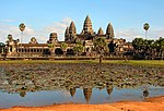
| អង្គរ | 
|
ខេត្តសៀមរាប, 13°26′N 103°50′E / 13.433°N 103.833°E |
Cultural: (i), (ii), (iii), (iv) |
1992 | Angkor is one of the most important archaeological sites in South-East Asia. Stretching over some 401 km2 = 40,000 hectares, including forested area, Angkor Archaeological Park contains the magnificent remains of the different capitals of the Khmer Empire, from the 9th to the 15th century. They include the famous Temple of Angkor Wat and, at Angkor Thom, the Bayon Temple with its countless sculptural decorations. UNESCO has set up a wide-ranging programme to safeguard this symbolic site and its surroundings. The site was listed as endangered from its inscription in times of political instability following the civil war in the 1980s to 2004. | [៣][៤] [៥] | |
| ប្រាសាទព្រះវិហារ | 
|
ខេត្តព្រះវិហារ, 14°23′18″N 104°41′2″E / 14.38833°N 104.68389°E |
Cultural: (i) |
155 (380); buffer zone 2,643 (6,530) | 2008 | Situated on the edge of a plateau that dominates the plain of Cambodia, the Temple of Preah Vihear is dedicated to Shiva. The Temple is composed of a series of sanctuaries linked by a system of pavements and staircases over an 800 metre long axis and dates back to the first half of the 11th century AD. Nevertheless, its complex history can be traced to the 9th century, when the hermitage was founded. This site is particularly well preserved, mainly due to its remote location. The site is exceptional for the quality of its architecture, which is adapted to the natural environment and the religious function of the temple, as well as for the exceptional quality of its carved stone ornamentation. | [៦] |
ឯកសារយោង
[កែប្រែ]- ↑ Cite error: Invalid
<ref>tag; no text was provided for refs namedlist - ↑ Cite error: Invalid
<ref>tag; no text was provided for refs namedcriteria - ↑ "Angkor". UNESCO. Retrieved 28 May 2010.
- ↑ 16th session 1992, ទទ. 37–38, annex VI
- ↑ 28th session 2004, ទទ. 66–67
- ↑ "Temple of Preah Vihear". UNESCO. Retrieved 28 May 2010.
